“Flying High In Florida captured our waterfront listing perfectly. The drone shots helped us sell in days, not weeks.”
— Mark R., Crystal River
Real stories from Florida’s sky-high perspectives. (Zoey approves these messages 🐾)
“Flying High In Florida captured our waterfront listing perfectly. The drone shots helped us sell in days, not weeks.”
— Mark R., Crystal River
“Jason & Kathleen delivered gorgeous event footage—crisp, cinematic, and perfectly timed to the music. Crowd went wild.”
— Lisa T., Hernando Beach
“Professional, creative, and fast turnarounds. The aerials gave our listing that ‘Florida wow’ buyers crave.”
— John D., Realtor, Dunnellon
Part 107 certified • Fully insured • Serving Florida’s Nature Coast & beyond


Drones aren’t just about epic sunset shots and fly-bys over turquoise water (though we do those pretty well). They’re also powerful tools for mapping — giving us an accurate, bird’s-eye view of the world with details that can make surveyors, engineers, and even treasure hunters giddy.
But if you’ve ever heard terms like orthomosaic maps, 3D point clouds, or digital elevation models and thought, “Uh-oh… this sounds like homework,” don’t worry. We’re about to make it crystal clear (and maybe even a little fun).
Imagine you took hundreds (or thousands) of photos from your drone and stitched them together so perfectly that the result was like one giant, high-resolution photo of the ground — but with zero distortion.

That’s an orthomosaic map.
Key features:
Extremely detailed and accurate (down to centimeters).
Perfect for measuring distances, areas, and boundaries.
Looks just like an aerial photograph — but with survey-grade precision.
Uses: Real estate property mapping, environmental studies, infrastructure inspections, construction site progress.
In short: Orthomosaics are like Google Earth, but so sharp you can spot your lost sunglasses.
Now picture the world made up of millions of tiny colored dots, each one representing a precise point in space. That’s a 3D point cloud.
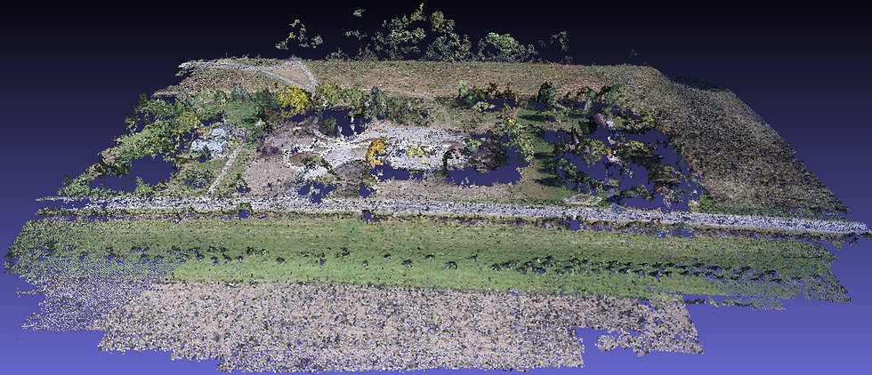
Key features:
Captures the shape and depth of objects.
Each “dot” has X, Y, Z coordinates and often color data.
Allows for detailed modeling of terrain, buildings, and structures.
Uses: Creating 3D models of construction sites, architectural visualization, bridge inspections, archaeological mapping.
In short: Point clouds are like the Matrix — but instead of green code, you get a vibrant, 3D reality you can rotate and explore.
A Digital Elevation Model focuses purely on height. It’s a 3D representation of the earth’s surface, showing you how high or low different areas are.

There are two main types:
Digital Surface Models (DSM): Show everything on the surface — trees, buildings, cars.
Digital Terrain Models (DTM): Strip away all that to show just the bare ground.
Key features:
Great for analyzing slopes, drainage, and flood risk.
Essential for planning construction or environmental restoration.
Uses: Civil engineering, environmental studies, flood modeling, land development.
In short: DEMs tell you where the hills are, where the water flows, and where you definitely shouldn’t build your dream tiki hut.
At Flying High In Florida, we don’t just capture stunning visuals — we create data-rich maps that help businesses, municipalities, and environmental groups make smarter decisions. Whether it’s mapping the shoreline after a storm, creating a 3D model of a property for sale, or helping plan infrastructure projects, we’ve got the tech (and the talent) to get it done.
From the skies to the shallows, our drones give you more than just pretty pictures — they give you insight.
Want to see your world from a new angle?
📩 Contact us at www.flyinghighinflorida.com and let’s map out your next project.


Comments